
By Joyce Chimbi
Unlike the rest of the ShimoniVanga seascape, the Indian Ocean waters around the Kisite-Mpunguti Marine Protected Area are a stunning crystal-clear blue, the air fresh and crisp. Even the skies are a breathtaking blue. But concerns are rife that this might not last.
Just 11 kilometres away, the Shimoni Fish Port, a project of the Kenya Ports Authority, is now complete. The port will begin operations in the next six months and has a capacity to handle up to 200 tons of fish per day. Conservationists and residents say the potential for environmental degradation far outweighs the expected economic benefits.
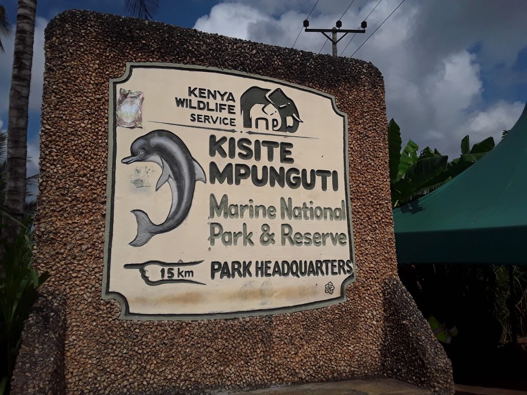
Fareed Musa, a local conservationist, says the Shimoni Fish port is a stone’s throw away from Kisite-Mpunguti Marine National Park and Reserve, one of 34 Blue Parks in the world today, recognised for meeting high, science-based standards for marine conservation effectiveness. The Blue Park Award has been presented annually since 2017. Blue Parks now cover over 3.5 million square kilometres (sq km) of ocean, spanning 23 countries, including Kenya.
Marine Conservation Institute’s rigorous science-based criteria and an international panel of esteemed marine scientists are key to vetting and ensuring that these MPAs provide examples of the most effective marine life conservation. The Kisite Mpunguti Marine Protected Area (MPA) was found to meet these standards.
Musa says the fish port goes against these high standards. Stressing that the park and its entire ecosystem “of mangrove forests, seagrass and coral reefs are greatly threatened.”
“First, we had the construction and dredging that led to coral bleaching or loss of colour in corals. We have a coral reef protected area, a mere two or three kilometres from the fish port, which will no doubt be damaged once operations begin due to heavy traffic.”
He says construction and dredging have already negatively impacted seagrass, coral, and mangrove restoration efforts in Wasini, an Island located just three kilometres from the Port and Kenya’s blue park. Musa shares that there are already talks between the national and the Kwale county government to expand the fish port and that such future activities will further exacerbate these negative impacts on the marine environment.
But senior officials from the Kenya Wildlife Service, who run the Kisite-Mpunguti Marine National Park and Reserve Park headquarters, at the shores of the Shimoni port, say the concerns are premature as modern facilities and environmental monitoring are included in the project. Still, Musa says there is no escaping habitat destruction once operations begin in the next six months.
“We expect increased marine traffic and, larger commercial fleets. These activities will introduce pollution from ships and will negatively affect marine life, and especially the fish population. With more and larger commercial fleets, the risk of overfishing is a big concern now,” he says.
Prof. Munene A. Mugo, an independent consultant in Wildlife and Conservation Law says a marine protected area or MPA is a specific area of the ocean, coastal, or Great Lakes region that is largely protected or managed for long-term conservation of its natural resources, ecosystems and cultural values. Governments establish MPAs to protect or shield marine ecosystems and other undersea resources from plunder, overexploitation and destruction.
Kenya’s system of MPAs consists of six marine national reserves: Kiunga, Malindi, Watamu, Mombasa, Diani-Chale and Mpunguti, and four marine national parks: Malindi, Watamu, Mombasa, and Kisite. They are all managed by the Kenya Wildlife Service. Kisite and Mpunguti join to form the Kisite-Mpunguti Marine Park, and is a particularly crucial MPA as it is Kenya’s first blue park and one of only 34 such parks in the world today, forming part of a global network of MPAs.
Abdul Hassan, a boat operator at the Shimoni Port, confirms that the park is fully protected. He says Shimoni is the “mainland port for Kisite. Visitors to the park buy their tickets from the Kenya Wildlife Service offices right here at the shores of Shimoni. The park is only accessible by water and only boats registered with the wildlife service can access the park. A boat trip from Shimoni port to Kisite-Mpunguti is about $150.”
Stressing that all the boats that operate at the Shimoni port “are registered with the Kenya Wildlife Service. Meaning that once you approach the park, the satellite will detect the approaching boat and if there is no record with the wildlife service showing that you are permitted to enter the protected area and for what reason, the Coast Guards will be dispatched to confront you. It is impossible to enter the protected area or conduct any activities undetected.”
Kisite Mpunguti Marine Conservation Area spans nearly 39 sq km. Bringing it under government protection has paid off. The blue park has abundant and vibrant marine life and is home to more than 250 recorded fish species including moray eels, butterfly fish, pufferfish, trigger fish, damselfish, wrasses, angelfish, parrotfish, groupers, snappers, scorpionfish, rays and, hawksbill turtles, green sea turtles and dolphins.
This protected area is known as the “Home of the Dolphin and Coconut Crab” due to the presence of dolphins and the largest land-living arthropod [animal with no internal spine] in the world – the coconut crab is endemic or regularly occurring to the marine protected area. Humpback whales and whale sharks are seasonal. Kisite Island is an Important Bird Area (IBA). IBAs are globally important habitats for the protection and conservation of bird population.
The magical natural wonders of Kisite-Mpunguti are nestled within the Shimoni-Vanga Seascape spanning over 860 sq km in the southern coastal region of Kenya’s Kwale County. Known for its abundant marine life and history, it encompasses the locations of Shimoni, a town with ancient slave caves, and Vanga, which features historical ruins and remnants of old settlements and tombs and, shares its southern Vanga boundary with Tanzania. Kisite-Mpunguti is just 8 kilometres North of the Tanzanian border.
ShimoniVanga is home to mangrove forests, seagrass beds, coral reefs, a variety of marine mammals, crustaceans, pelagic and demersal fishes, cephalopods such as octopus, squids, and cuttlefish, and echinoderms, birds, and reptiles. Natural wonders are such that the river Ramisi cuts through the seascape to drain into the Indian Ocean. The imposing river is only accessible by boat as dense mangrove canopies line its banks.
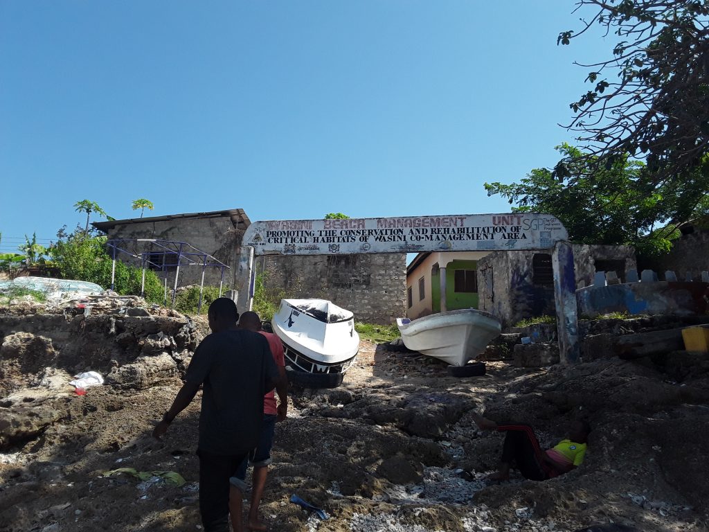
Nearby Wasini Island is a popular tourist destination as it is a melting pot of cultures, with influences from the Arab and Portuguese historical periods. The island is in proximity to the Kisite-Mpunguti Marine Park and Reserve. Across the entire seascape, Wasini stands out as a melting pot for community-led conservation efforts that have helped promote sustainable tourism in all the villages that surround Kisite-Mpunguti.
Mariam Juma, a local conservationist who participates in the Wasini Mangrove and Coral Garden conservation project, says this is “one of the many community-led projects in Wasini Island. The entrance into the Island is a big banner that speaks of the promotion, conservation and rehabilitation of Wasini habitats.” She fears that the Island’s extensive conservation efforts will be derailed by the expected beehive of activities at the Shimoni Fish Port.
Juma is concerned that these activities could expose the blue park to many of the challenges plaguing Kenya’s Indian Ocean waters. Abdalla Ali, an official at the Kwale County government, says the primary threats to sustainable use of Kenya’s waters are caused by “human economic activities such as over-fishing and destructive fishing techniques such as poison fishing – where fishermen grind plants that are harmful to the fish but safe to humans and throw them in the ocean.”
“The fish run to the water surface for safety or die and float at the surface and into the fishermen’s nets. This is extremely dangerous as the poison is not selective and kills all marine life. It is a traditional method favoured by artisanal or small-scale fishermen. Some of them use pesticides to catch fish.”
In varying degrees, these threats are common across the ShimoniVanga seascape but not in and around the Kisite-Mpunguti blue park or even in the neighbouring Wasini Island. However, locals say this might change as people move to villages around the fish port in search of job opportunities.
Other threats within the seascape include dynamite or bomb fishing and the use of small-mesh nets and, the over-harvesting of other marine products including seabirds, mangroves, shells, turtles, marine invertebrates and mammals.
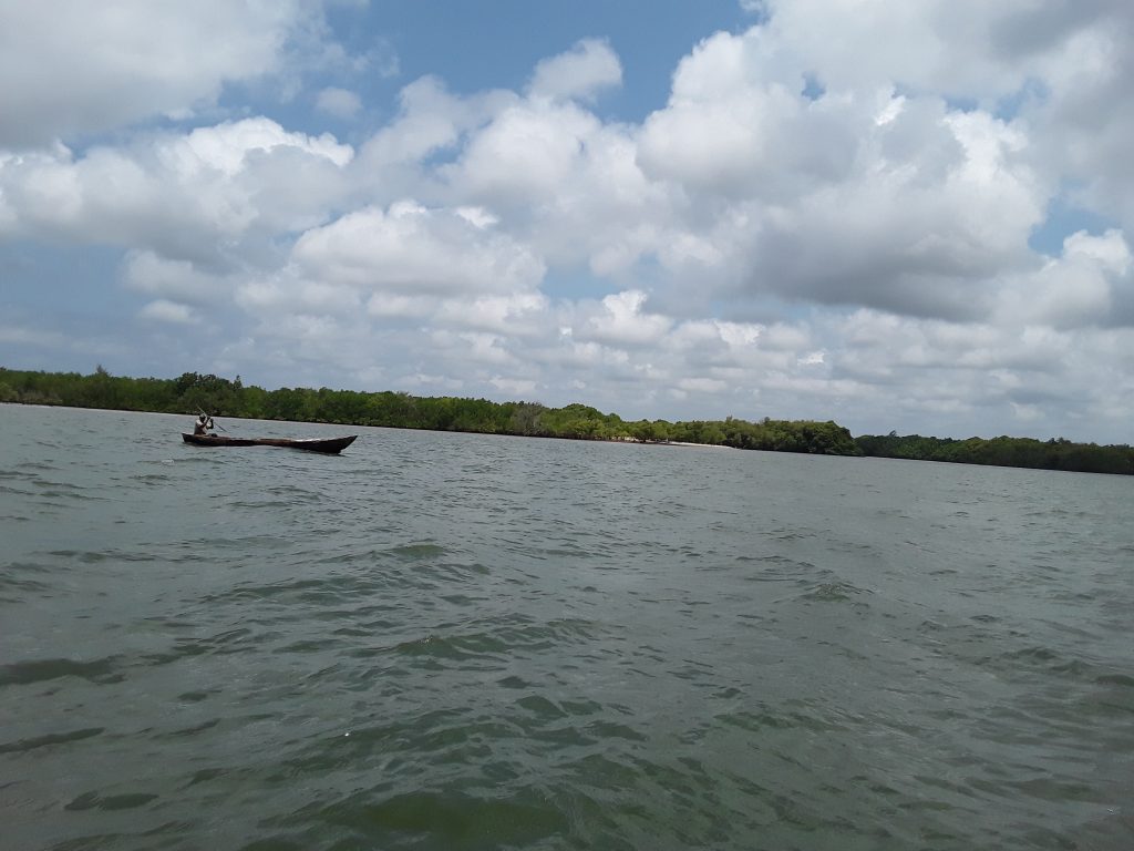
Deep inside Ramisi river, artisanal fishermen can be seen going about their activities. Further ahead at the river’s bank are some of the uninhabited areas which remain untouched by human activities. Photo Joyce Chimbi.jpg
Locals such as Musa say “over-harvesting of turtles in our ocean within Kwale County [where the seascape is located] is highly concerning, as it takes one turtle 30 years or more to mature. It takes a green turtle 20 to 30 years, and at times even more, to mature and a hawksbill 20 to 25 years.”
Pollution of natural habitats from land reclamation, shipping, ports, urban centres, tourist developments and industries, including prawn farming, salt production, oil and gas extraction, is a most pressing concern along the seascape, as is climate change.
All these challenges, locals say, will be sustainably addressed by bringing more marine areas under protection and co-management of ocean resources between the government and local communities, as has been clearly demonstrated by the Kisite-Mpunguti blue park and neighbouring Wasini Island.
Gerald O. Otieno, a senior government official and conservationist with the Ministry of Mining, Blue Economy and Maritime Affairs says despite these threats and challenges, Kenya is moving in the right direction in all matter’s marine conservation, and is on track to bring at least 30 percent of land, freshwaters and oceans under protection by 2030, in line with the 30×30 global target.
30×30 is a commitment within the Convention on Biological Diversity Framework, recognising the importance of conserving biodiversity and ecosystems through protected areas and other effective conservation measures. Otieno emphasises that the Kenyan government is demonstrating its strong commitment to this worldwide initiative.
Stressing that as a result of this demonstrated commitment, this East African nation has earned the “honour to host the 11th Our Ocean Conference (OOC) in March 2026 in Mombasa County, which neighbours Kwale County where Kisite-Mpunguti MPA is located. This is the first time the global summit will be held in Africa, placing the continent at the centre of global conversations on ocean governance and the sustainable blue economy.”
He says the conference is an opportunity for Kenya to showcase its marine resources and innovations, highlight African blue economy opportunities, and champion sustainable solutions for the world’s oceans.
Prof. Mugo says, while this might be the case, “the government continues to sidestep serious policy challenges in marine protection. There is still weak enforcement of existing laws and uncoordinated sectoral policies.”
“Sometimes there is opposition from the community against government conservation activities such as those related to the establishment of no-take zones, or areas where you cannot extract marine resources. This is often due to a lack of community engagement and support for alternative livelihoods outside the ocean such as farming and trade.”
Salim Abedi, founder of ShimoniVanga Nature Trails, a community-based organisation, says Kenya is making “one step forward and another backwards.”
“The issue of mushrooming ports is a primary concern as we also have the Port of Lamu, which is part of the Lamu Port-South Sudan-Ethiopia Transport (LAPSSET) Corridor Program. This is a deep-sea port and it also indirectly affects the ShimoniVanga seascape due to increased regional maritime traffic and the pollution that will come from larger vessels.”
Juma agrees. The local conservationist says mushrooming ports and their expansion reflect a contradiction in policy, “and especially because the size under marine protection pales in comparison to global marine protected areas. We expected to see a policy push to bring even more marine areas under protection.”
Overall, Kenya’s six MPAs cover a total area of 825 sq km. For comparison, the French Polynesian Marine Protected Area is the world’s largest, covering approximately 4.8 million sq km, with a large portion of that set aside as highly protected or no-take zones. The 10th largest MPA in the world is the French Southern Territories and High Seas, spanning over an estimated 660,026 sq km.
But government officials such as Otieno say this is not a fair comparison as Kenya’s coastline measures nearly 600 kilometres from the Somalia to the Tanzania border, and that the country should be lauded for what has been achieved thus far, as “all marine parks in Kenya are no-take zones. We do not allow any resource exploitation or extraction. In marine reserves, there is limited extraction of resources and this is closely monitored.”
“With that size in mind, we have made commendable progress towards increasing the total coverage of MPAs. Kenya is home to six out of 16,545 MPAs in the world. All six MPAs are well managed and highly beneficial, increasing income-generating activities for our tour operators, boat owners and fishermen, while also protecting, conserving and preserving the rich biodiversity.”
Others like Juma see it differently. Stressing that the country is operating under its full capacity on all matters of marine protection, especially in light of the many complex challenges that he says are pushing Kenya’s coast further away from protection.
She says the government continues to turn a blind eye to investors who are endangering the seascape’s marine resources through unsustainable tourism practices such as destructive fishing and habitat disturbance. Emphasising that these activities degrade the delicate seagrass beds and coral reefs, as does unsustainable coastal development like mangrove conversion.
“There is the complex issue of land ownership in the coastal region. Kenya’s land laws are very clear about the acquisition of beachfront property. But again, we have seen amendments that enable non-citizens to buy first and second row beachfront property and land within 25 kilometres from the inland boundary of Kenya. Unlike before, this can be done without the written consent of the land’s minister, meaning there are loopholes in oversight,” she says.
In Kenya’s coastal areas, land boundary requirements include establishing a riparian reserve of 6-30 meters from water bodies, conducting a formal survey by a licensed surveyor to create a survey plan, and ensuring that the land boundaries exclude this reserve. All developments near or within riparian areas require an Environmental Impact Assessment by the National Environment Management Authority (NEMA) or a project report.
“When the land was in the hands of the community, they traditionally maintained a riparian reserve of about 60 meters from the water bodies. Today, we hear it is 6 to 30 meters and boundary marks are protected by law in words only,” says Juma.
“Along the ShimoniVanga seascape, you will see beachfront properties on the shores. This then becomes private property and the local community that traditionally protects these areas is blocked from accessing them. The government cannot sustain conservation efforts without the support of the local community.”
Ali, the official at the Kwale County government, where the seascape is situated, says Juma’s concerns are currently being addressed through the Shimoni-Vanga Joint Co-Management Area (JCMA) Plan. “This plan was developed through multi-stakeholder engagement and included residents from Shimoni, Vanga and Wasini Island,” he expounds.
He nonetheless concedes that the plan is a local co-management plan rather than a comprehensive Marine Spatial Plan. Marine Protected Areas in Kenya require a Marine Spatial Plan to systematically manage human activities and achieve ecological, economic and social objectives in the marine environment. These plans are crucial for the sustainable use and protection of marine resources, especially in light of human impacts and climate change.
Ali says local co-management is equally important to guide sustainable management of marine resources and activities within the seascape, as some of the threats to marine life come from the community. Prof. Mugo says while these efforts are a step in the right direction, “existing policy gaps will derail progress towards 30×30.”
“Kenya still lacks a comprehensive legal and institutional framework for efficient and effective management of marine resources and especially fisheries. The government is still using the top-bottom approach and they are therefore not involving local communities and the private sector in meaningful decision-making towards sustainable ocean protection. Even when government officials hold public participation forums, it is often a ceremonial activity to check off a constitutional requirement.”
He says sidelining the community is counterproductive as they are the ones closest to marine resources. Along the seascape are seven villages, including Shimoni, Majoreni, Vanga, Jimbo, Kibuyuni, Wasini, and Mkwiro, all depending on the natural wonderland for their survival but restricted from the 39 sq km of the Kisite-Mpunguti Marine Park and Reserve.
Further north is the Kiunga Marine National Reserve which is constituted by a chain of nearly 50 offshore islands and coral reefs in the Lamu Archipelago. He says there are more than 2632 fishers in the Shimoni-Vanga Seascape and that migrant fishers and, illegal fishing gear such as spear guns and beach seines, are frequently spotted.
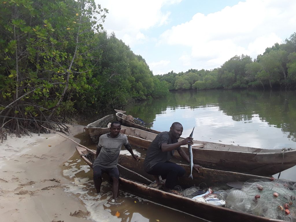
A trip down Ramisi River through many of these villages reveals a high number of artisanal fishermen and many of their activities are undetected and therefore, unregulated. Local government and communities are jointly working to combat destructive fishing methods such as spear gun fishing, poison fishing and bottom trawling through the Beach Management Units.
A Beach Management Unit (BMU) is a legally recognised community-based organisation that brings together all community members who traditionally depend on fisheries activities. The seascape is a focal point for community-led marine conservation. There are seven BMUs in Shimoni-Vanga, each representing one seascape community.
These BMUs work towards improved governance and management of the seascape, including ensuring compliance to regulations on local and national resource use and are critical to combating illegal, unreported and unregulated (IUU) fishing. According to the government, Kenya loses an estimated KSh45 billion [about US$348 million] annually to illegal and unregulated fishing, from missed revenue due to a lack of licensing and proper regulation.
Spear gun fishing is common among artisanal fishermen in the seascape. It involves breaking corals and harming breeding grounds, leading to fish migration. Bottom trawling is used in industrial fishing and has also been detected in the seascape, leading to the destruction of marine habitats like coral reefs and seagrass beds.
Otieno, the government conservationist, says while challenges abound and pressing, progress in marine protection is “undeniable. Parts of the seascape are completely untouched by human activity. Except for Wasini Island, the ShimoniVanga seascape comprises the uninhabited Mpunguti ya juu, Mpunguti ya Chini, Mako Kokwe, and Sii coral islets. These areas are under natural protection and we intend to keep them that way as we work towards formally and officially bringing them under protection.”
After all is said and done, Juma and other local conservationists insist Kenya has only scratched the surface. That, despite Kenya having the oldest MPAs in Africa, progress towards 30×30 is slow, at times scanty amidst financial constraint.
The current total allocation for environmental protection, water and natural resources stands at Ksh103.8 billion [$797 million], a drop from Ksh110.1 billion [$851.5 million] from the 2023/2024 budget. In the backdrop of this and other constraints, how Kenya progresses towards 30×30 is a matter of wait and see.
Prof. Mugo says “alongside dire financial constraints are many pressing challenges such as the ongoing ocean-grabbing scramble for Indian Ocean resources, marine pollution and overall environmental degradation. The dangers and risks to marine life are only multiplying.”
“These threats far outweigh existing legal frameworks and interventions. The government needs to urgently rethink its approach to ocean protection before the damage becomes irreversible and we are certainly running out of time,” he emphasises.
This story was developed with support from the Earth Journalism Network


